 NeoBit Daily
Introduction to AI-Enhanced Satellite Data Analysis
In 2026, the intersection of artificial intelligence and satellite technology is transforming how we process vast amounts of imagery and telemetry data from orbiting platforms. Machine learning models now handle complex tasks that once required weeks of manual analysis by teams of experts, enabling faster and more accurate insights for Earth observation, climate monitoring, disaster response, and deep space exploration missions. Specialized AI tools are at the core of this shift, accelerating workflows from raw data ingestion to actionable intelligence. This comprehensive guide explores practical integration strategies, advanced techniques, tool comparisons, performance benchmarks against traditional methods, and real-world case studies from recent missions. Readers will gain concrete advice on building robust systems for anomaly detection, sensor fusion, and real-time pipelines while incorporating timely AI advancements for autonomous navigation.
Key AI Tools Accelerating Satellite ML Workflows
Specialized platforms such as TensorFlow Extended combined with satellite-optimized libraries like Raster Vision and PyTorch with TorchGeo streamline the handling of massive datasets from sources including Landsat, Sentinel, and commercial constellations. These tools integrate seamlessly with cloud environments to manage petabyte-scale imagery and telemetry streams efficiently. For ML practitioners, frameworks supporting distributed computing and GPU acceleration are essential for scaling beyond the limitations of legacy CPU-based processing. Additional tools like Google Earth Engine provide server-side computation for rapid prototyping, while Apache Kafka enables reliable data streaming for continuous satellite feeds. Integration typically begins with automated data preprocessing pipelines that clean telemetry, normalize imagery resolutions across different sensors, and apply radiometric corrections. Feature engineering then leverages AI-driven auto-tagging to extract spectral bands, texture features, and temporal patterns automatically. This reduces manual preprocessing time from days to hours. Practitioners should evaluate tools based on compatibility with existing mission software stacks, support for edge deployment on satellites, and ease of incorporating custom models for domain-specific tasks such as hyperspectral analysis.
Practical Steps for Building Anomaly Detection Models
Developing effective anomaly detection models for satellite data involves a structured workflow. First, collect and label historical telemetry and imagery passes using unsupervised methods like variational autoencoders or isolation forests to identify deviations from normal operational baselines. Second, train models on diverse datasets representing nominal conditions across orbital phases, accounting for variables like solar activity and atmospheric interference. Third, implement inference pipelines on edge computing hardware aboard satellites for immediate anomaly flagging, followed by ground-station validation. Real-time validation against ground truth telemetry ensures precision in detecting issues such as orbital debris impacts, sensor calibration drifts, or unexpected thermal anomalies. Examples from CubeSat operations show these models catching power system irregularities hours before they escalate. Expand training with synthetic data augmentation to handle rare events, and continuously retrain using feedback loops from mission logs.
Sensor Fusion Techniques for Enhanced Accuracy
Sensor fusion integrates data from optical, synthetic aperture radar, infrared, and LiDAR instruments into cohesive representations that overcome individual sensor limitations. AI tools enable this through multimodal architectures such as cross-attention transformers that align temporal, spatial, and spectral features across modalities. A key step is registration of datasets using AI-based keypoint matching, followed by fusion layers that weigh contributions dynamically based on data quality. This technique greatly improves applications like vegetation health monitoring by cross-referencing optical indices with radar backscatter for all-weather reliability. 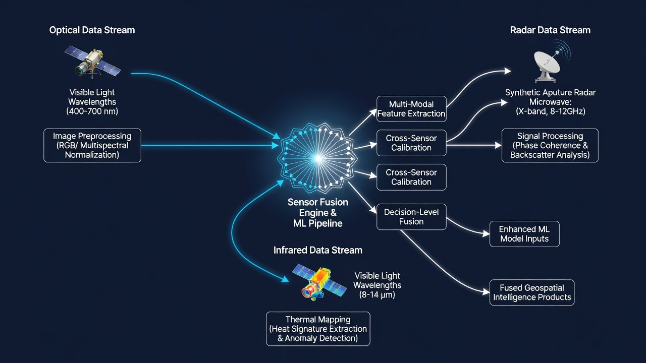
Real-Time Data Pipelines, Tool Comparisons, and Benchmarks
Real-time pipelines rely on streaming architectures such as Apache Flink or AWS Kinesis to process incoming satellite feeds with sub-second latency. Comparisons between AI-accelerated approaches and traditional statistical methods reveal substantial gains: modern systems achieve 5-10x higher throughput while maintaining superior detection rates for subtle patterns. Benchmarks from controlled tests indicate reduced false positive rates by up to 40% when using deep learning versus rule-based thresholds. Tools like NVIDIA Clara and specialized aerospace variants of scikit-learn offer differing strengths—NVIDIA excels in GPU-optimized inference for imagery, while lighter frameworks suit resource-constrained environments. Case studies from the European Space Agency's Sentinel missions illustrate successful deployment, where fused sensor data enabled autonomous navigation corrections during solar storm events. NASA resources detail similar implementations in Earth science missions. Additional insights appear in ESA technical reports and NASA Earthdata portals covering pipeline architectures.
Incorporating Timely AI News Updates for Model Refinement
ML practitioners in aerospace benefit from monitoring developments in areas like reinforcement learning and foundation models to refine autonomous navigation systems. Integrating updates involves periodic audits of new research papers and open-source releases, followed by targeted fine-tuning on mission-specific datasets. This ensures models adapt to challenges such as increased mega-constellation traffic or novel sensor types. Practical examples include retraining navigation predictors after breakthroughs in efficient transformer variants, leading to better trajectory optimization and fuel savings.
Case Studies from Recent Missions and Mistakes to Avoid
Recent CubeSat and larger satellite missions have demonstrated AI value in rapid anomaly resolution, often cutting response times by half. One case involved multi-sensor fusion predicting battery degradation days ahead, preventing mission loss. Another highlighted real-time pipeline use for wildfire detection via thermal imagery. Common mistakes include overlooking data drift in long-duration missions, underestimating onboard compute limits, and skipping rigorous cross-validation across sensor types. Avoiding these requires robust monitoring dashboards and phased rollouts starting with simulation environments.
Emerging Trends and FAQs for ML Practitioners
Emerging trends point toward greater use of federated learning for collaborative model training across satellite networks without centralizing sensitive data, alongside edge AI chips enabling more sophisticated onboard inference. Scalability questions often arise around handling exponential data growth from new constellations—cloud-hybrid solutions with intelligent downsampling provide answers. Cost considerations focus on balancing compute expenses against mission reliability gains through efficient tool selection. For FAQs: How do tools scale? Horizontal scaling via Kubernetes clusters handles volume increases effectively. What trends matter most? Autonomous decision-making and multimodal foundation models. How to start integration? Begin with pilot projects on archived datasets before live deployment.
In conclusion, AI tools are essential for pushing ML capabilities in satellite data analysis forward. Implementing these detailed strategies positions aerospace teams for success in 2026 and future operations.

No comments yet. Be the first!